God’s own country- so let God do it or should we do our part before the next disaster strike us.
 Context

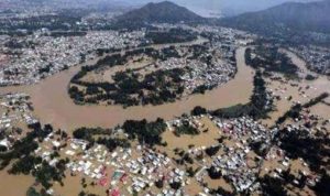
The recent floods had surely harnessed Keralites across the globe irrespective of their gender, age, religion or class but its impact manifest continue spatially beyond the event. It is an eye opener for many of our systemic deficiencies but also presents an opportunity for certain practical and bold actions, much beyond the event’s impact. Adequate precautions, control of authorised and unauthorized encroachments and constructions, afforestation, climate resilient structures are all the more a necessity for disaster prone state like Kerala to mitigate the disproportionate amount of risk. The invisible extend of this cumulative risk trap of excessive rain, flood, landslide, earthquake, tsunami and cyclones may impact substantial damages in future in a level 3 disaster prone state like Kerala.
Vulnerable sectors are forced to live under stressed environmental conditions and they form pressure groups that influence the successive governments. Doers are currently reactive on short term necessities , politics is busy on post-mortem and environmentalists busy advocating long terms like Gadgil Report, development vs environment, total solar energy, total abolition of quarries, dams etc.
Let us first agree that natural hazards are unavoidable and total protection against most of it is not feasible even if there is a remote possibility. However with my experience as an Urban & Regional Planner who was involved in many Master Plans, Water Infrastructure and Water Front projects, few practical thoughts which many countries have implemented and can be implemented in next 5 years to mitigate impacts on people, animals and property are discussed here under. Recommendations for climate resilient housing for further reviews and refinements are also included. This could ensure a balance currently and long term social, environmental and economical sustainability and pray that this do not raise controversies but some constructive updates and implementation.
Disaster Risk Models(RCM) and Model Driven Integrated Disaster Management Protocol (IDMP)
Integrated Risk management models shall be created for each of the main potential disaster threats in Kerala namely Heavy Rains resulting in Flood & Landslide, Cyclones, Dam Break, Earth Quake and Tsunami. These models shall be simulated with known historical data for validation and also model shall be run for various risk scenarios.
A comprehensive and integrated disaster management protocol shall be established for post and past disaster actions based on the simulation model for disasters like Earth Quake, Tsunami, Excessive Rain, Flood, Landslide and Cyclones.
The current focus of rebuilding with a budget of 30,000 crores should not just focus on reconstructions of the damaged but on Integrated Disaster Management (IDM) planning and Climate Resilient Constructions (CRC).
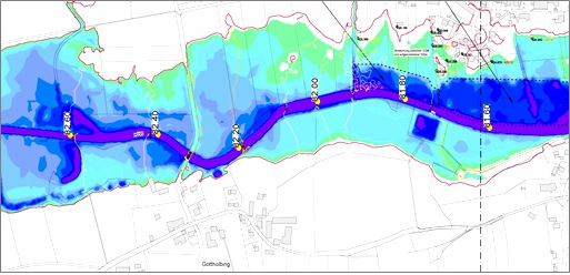
Flood Inundation Model (FIM)
An actual reference flood inundation model and hazard map shall be developed after assimilating and tabulating all actual flood data collected from various affected places from across the state, immediately with coordinates and current land levels on a high resolution terrain data. Rain historical date, rain fall run offs, land levels, land use, quantified drainage maps, hydraulic structures, protection barriers etc shall be included in the terrain models.
The flood hazard levels, zone and flood direction is to be clearly identified and marked taking in to account the fluvial, storm surge, dam discharges and tidal pressures & variations.
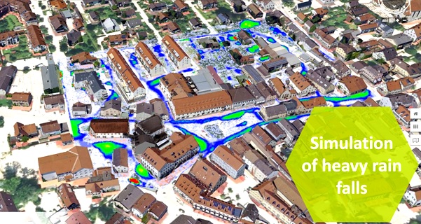
Hydraulic Modelling Water Level Calculations
The model shall be capable of simulations based on real time and predicted dam levels, rain fall data of the catchments, strong flow conditions upstream and downstream, urban network of streets and other facilities. The model should clearly provide flood behaviour and risk, construction impacts and support in flood plain planning and water quality modelling based on real time and historical rain fall and soil data. The digital terrain base model shall be either from validated and verified satellite data or from laser surveys.
Integrated Rain, Flood and Landslide Management Protocol
An integrated heavy rain, flood and landslide management protocol shall be established for post and past disaster actions based on the rain and flood model. Flood action shall include hydrostatic, hydrodynamic, debris management, erosion control actions around dams, rivers, water bodies, major transportation routes, power, water supply and communication systems. These shall not be done in isolation but integrated for the entire state connecting various interlinked flood paths and facilities. Protocol shall be established for various stages of flood levels and catchment rain fall based on the weather forecast from a competent meteorological authority. Competence of the meteorological authority shall be ensured during non disaster periods and they shall be fully trusted during the disaster periods. This protocol should limit discretionary powers of individuals in position to avoid influence of the pressure or interest groups in case of emergency situations as has been criticised now. The authority responsible for enforcing the protocol shall not be part of beneficiary authority like the electricity board or the affected authority like the revenue department but shall be an independent authority like the disaster management authority preferably directly under the state Chief Minister. Safety of people and their property shall be the prime considerations during the disaster management periods. The protocol shall ensure precautionary level reductions in lower reservoirs well in advance, alert levels with water levels in dams and advance water levels against time across the state based on rain fall data and dam water release and forecast. The protocol should also include for a dam break situation, intervention maps for operational planning, early warning systems, emergency alerts and evacuation plans to mitigate dangers.
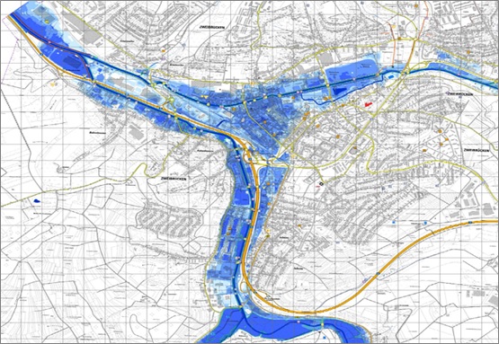
Intervention Maps
Drought and Washed soil
The flood should have washed away the mineral rich water retaining and infiltrating top soil from most of the sloped areas. These would have been deposited in lower plains and rivers near the sea and flat plains. This on one side leads to ground lower water replenishment at upper areas and depletion at mid level and may increase the speed of the rivers till the plains. The deposits at plains further increase chances of floods in the plains. There are no immediate solutions to these issues but water harvesting by rain pits, water retention by mulching &organic fertilising, soil retention by retaining walls in mild slopes , water breaks by small trenches, etc, will gradually support in reducing further depletion. The effectiveness of de-silting at down streams and small check dams may also be studied. Previous restrictions on sand mining from river beds may be revisited as it will both clear the water ways and reduce quarrying. The beneficiary local body namely the Panchayats, should be able to convince their political bosses to resist the pressure from the quarry lobbies.
Refurbishment or Re-construction
The spatial development namely Refurbishment or Re construction of damaged houses, roads, bridges and other facilities shall be climate resilient. The structures that can be refurbished are to be refurbished. Re-architecture, a terminology not often used and practised in this region despite best efforts by my associate, shall be given its due importance to make these constructions climate resilient. First the location and its levels are to be validated by a competent firm irrespective of whether it satisfies the current regulatory and legal requirements. If found suitable, climate resilient structures sensitive to the region may be constructed taking in to account the following aspects:
- Ring beams when existing foundations are to be reused to avoid differential settlements
- Solid anchored diversions/ depressions, pile foundations, Elevated structures on tapered columns may be considered in landslide prone sites if constructions in those areas are unavoidable.
- Septic tanks shall be with NRV’s
- The design shall be modular to suit the cash flow in 3 to 4 phases.
- Precast or prefab constructions with CFRG, Concrete, Composite Wood, Metal, etc, may be considered to speed up rehabilitation.
- Elevated and porous structures that has ‘’open to failure’’ door-window-ventilator openings may be considered in flood prone area
- Open stair accessible from outside at all level
Planning Policy Changes:
The current zoning map for the cities and for EFL areas are inadequate and in many cases not useful. Comprehensive spatial master plans shall be developed for each of these areas with definite development control regulations (DCR’s) that define extend, stability, connectivity, features, materials and character of the developments. Planning policy that ignores the construction needs and the commercial potential are not practical as these often end up as a tool for corruption and eventual unethical constructions. The connectivity and the current capacity of roads are to be given its due importance. The planning decisions and zoning shall be practical and market sensitive and should ensure social, environmental economical sustainability for all stake holders and should not be just to win the galleries.
Building Rule Changes
Successive governments often do zig zag in building rules. Normally ideological at start limiting construction with strict FAR & coverage rules and later reverting to even more liberal conditions and accepting the illegal structures succumbing to pressure groups.
Many ironies in the building rules have to be reversed. Example the parking rules.
- FAR & coverage based on road width in front irrespective of its carrying capacity and its connectivity.
- Drainage shall be given its due importance and DCR to control the gate and ground levels and to ensure the drainage capacity based on 90 or 150 year storm data.
- Porous podiums in place of basements
- Life safety provisions as per international standards as current rules are inadequate.
- Mandatory Fire and flood compartmentalisation
- Mandatory Flood, Gate and GF levels approvals.
- Regulations on construction materials to be used.
- Permits for plans, Architectural and Structural designs shall be issued to Planners, Architects and Structural Engineers and not to the land owner, and the same Planners, Architects and Structural Engineers should be entrusted to issue the completion certificates with appropriate check points and redressal forums.
Implementation
The implementation often fails in a free and highly political state like Kerala where interest and pressure groups get away with many rules. But blaming the government or the authorities for all issues will never solve this problem, but planning for the existing situation and realities will. A long term solution for proper implementation control is currently available through the developing Interactive Building Information Modelling (IBIM) technology wherein the full life cycle of the project can be monitored, controlled and regulated much beyond the current permit issue stage. These shall be done at least for the areas that are affected by the current flood plus a defined safety level now and for rest of the areas in the coming years.
- As a step one the land, water, soil and current asset data base model shall be created with support of asset owners and competent agencies themselves.
- The building information model certified by a licensed architect or engineer shall be uploaded in appropriate coordinates.
- Flood model simulation shall be made for all the assets within the flood safety level and the river width and flood path shall be managed accordingly. Appropriate protection, safety, evacuation and management plan shall be created within the model.
- A dam break analysis and its simulation and suitable protection, safety, evacuation and management plan shall also be created within the model.
- Any encroachments, unlawful constructions, etc shall be highlighted and designated for evacuation and demolition.
- Real time Water quality modelling and simulation shall also be done to monitor and control the water quality.
Management
A technology driven Facility Management Centre reporting directly to a ministry shall be created in every Corporation, Municipality and Panchayats. This centre shall be responsible for all licensing, permitting and its renewals based on environmental capacity of the land after analysing the environmental costs and impacts for new developments, buildings, factories and industries. Protocols shall be developed for existing facilities to mitigate the environmental damages that they are causing and to ensure that they also function within the environmental capacity. All the local authorities shall report to this centre during such disasters.
This centre shall function through an online integrated facility management system with lesser human involvement. This centre shall further be responsible for monitoring, control and management of climate response systems by taking real time sensor inputs and historical data based modelling. The centre will also be able to advise and promote sustainable agriculture and sustainable tourism, a life line of Kerala in the coming decades.
Such a centre with an authority on licensing and renewing new facilities and climiate response systems will ensure environmentally, sociailly and economically sustainable Kerala.
Brief:
Mathews George B.E. AG. DMM, MSc URP, MRTPI is one of few Chartered Town Planner of Royal Town Planning Institute of UK based in India and a Water Counsultant who did many Water Master Plans while he was associated with Aecom and Hyder- Arcadis , world’s leading Infrastructure Consultants. He is the director of Arkind Consultants an award winning Planning, Landscape & Architectural Consultancy Group.
Mathews George B.E. AG. DMM, MSc URP, MRTPI
Chartered Town Planner of Royal Town Planning Institute of UK